By road, Marrakesh is located 580 kilometres (360 mi) southwest of Tangier, 327 kilometres (203 mi) southwest of the Moroccan capital of Rabat, 239 kilometres (149 mi) southwest of Casablanca, 196 kilometres (122 mi) southwest of Beni Mellal, 177 kilometres (110 mi) east of Essaouira, and 246 kilometres (153 mi) northeast of Agadir.[43] The city has expanded north from the old centre with suburbs such as Daoudiate, Diour El Massakine, Yamama, Sidi Abbad, Sakar, and Malizia, to the southeast with Sidi Youssef Ben Ali, to the west with Massima, and southwest to Hay Annahda, Berradi and beyond the airport.[43] On the P2017 road leading south out of the city are large villages such as Douar Lahna, Touggana, Lagouassem, and Lahebichate, leading eventually through desert to the town of Tahnaout at the edge of the High Atlas, the highest mountainous barrier in North Africa.[43] The average elevation of the snow-covered High Atlas lies above 3,000 metres (9,800 ft). It is mainly composed of Jurassic limestone. The mountain range runs along the Atlantic coast, then rises to the east of Agadir and extends northeast into Algeria before disappearing into Tunisia.
The Ourika River valley
The Ourika River valley is located about 30 kilometres (19 mi) south of Marrakesh.[45] The "silvery valley of the Ourika river curving north towards Marrakesh", and the "red heights of Jebel Yagour still capped with snow" to the south are sights in this area.[46] David Prescott Barrows, who describes Marrakesh as Morocco's "strangest city", describes the landscape in the following terms: "The city lies some fifteen or twenty miles [25–30 km] from the foot of the Atlas mountains, which here rise to their grandest proportions. The spectacle of the mountains is superb. Through the clear desert air the eye can follow the rugged contours of the range for great distances to the north and eastward. The winter snows mantle them with white, and the turquoise sky gives a setting for their grey rocks and gleaming caps that is of unrivaled beauty.
With 130,000 hectares of greenery and over 180,000 palm trees in its Palmeraie, Marrakesh is an oasis of rich plant variety. Throughout the seasons, fragrant orange, fig, pomegranate and olive trees display their color and fruits in Agdal Garden, Menara Garden and other gardens in the city.[47] The city's gardens feature numerous native plants alongside other species that have been imported over the course of the centuries, including giant bamboos, yuccas, papyrus, palm trees, banana trees, cypress, philodendrons, rose bushes, bougainvilleas, pines and various kinds of cactus plants.

****Jemaa el-Fnaa***
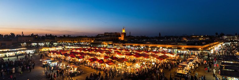
The Jemaa el-Fnaa is one of the best-known squares in Africa and is the centre of city activity and trade. It has been described as a "world-famous square", "a metaphorical urban icon, a bridge between the past and the present, the place where (spectacularized) Moroccan tradition encounters modernity. It has been part of the UNESCO World Heritage site since 1985. The name roughly means "the assembly of trespassers" or malefactors.] Jemaa el-Fnaa was renovated along with much of the Marrakech city, whose walls were extended by Abu Yaqub Yusuf and particularly by Yaqub al-Mansur in 1147–1158. The surrounding mosque, palace, hospital, parade ground and gardens around the edges of the marketplace were also overhauled, and the Kasbah was fortified. Subsequently, with the fluctuating fortunes of the city, Jemaa el-Fnaa saw periods of decline and renewal. Historically this square was used for public decapitations by rulers who sought to maintain their power by frightening the public. The square attracted dwellers from the surrounding desert and mountains to trade here, and stalls were raised in the square from early in its history. The square attracted tradesmen, snake charmers ("wild, dark, frenzied men with long disheveled hair falling over their naked shoulders"), dancing boys of the Chleuh Atlas tribe, and musicians playing pipes, tambourines and African drums.Richard Hamilton said that Jemaa el-Fnaa once "reeked of Berber particularism, of backward-looking, ill-educated countrymen, rather than the reformist, pan-Arab internationalism and command economy that were the imagined future. Today the square attracts people from a diversity of social and ethnic backgrounds and tourists from all around the world. Snake charmers, acrobats, magicians, mystics, musicians, monkey trainers, herb sellers, story-tellers, dentists, pickpockets, and entertainers in medieval garb still populate the square
****Menara gardens****
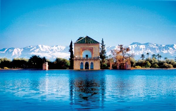
The Menara gardens (Arabic: حدائق المنارة) are botanical gardens located to the west of Marrakech, Morocco, near the Atlas Mountains. They were established in the 12th century (c. 1130) by the Almohad Caliphate ruler Abd al-Mu'min.
El-Menara at sunset, April 2013
The name menara derives from the pavilion with its small green pyramid-shaped roof (menzeh), meaning lighthouse (منارَة [manaara]). Although there is no actual lighthouse in the gardens, any building that sits at a high elevation is locally known as menara, such as the mosque Menaret manaara. The pavilion was built during the 16th century Saadi dynasty and renovated in 1869 by sultan Abderrahmane of Morocco, who used to stay here in summertime.

The Menara gardens
The pavilion and basin (an artificial lake) are surrounded by orchards and olive groves. The intention of the basin was to irrigate the surrounding gardens and orchards using a sophisticated system of underground channels called a qanat. The basin is supplied with water thanks to an old hydraulic system, which conveys water from the mountains located approximately 30 km away from Marrakech. It also served as a martial station.
beautiful place
Thank you
Hi! I am a robot. I just upvoted you! I found similar content that readers might be interested in:
https://en.wikipedia.org/wiki/Marrakesh
Thank you