Forests currently cover around 30% of the world's land area, even as human activity—mainly agriculture and commodity production—clears forested areas at an estimated 27 football (soccer) fields per minute. If current rates continue, rainforests could disappear completely within a hundred years. And even if that never comes to pass, deforestation is already having terrible consequences:
Deforestation is a driver of climate change. Human activity when cutting down forests contributes around 12% of the world's total CO2 emissions. Furthermore, trees act as carbon sinks because they convert atmospheric CO2 into their own biomass as they grow.
Deforestation leads to habitat loss. It's estimated that around 80% of land animals and plants make their living in forests. Loss of biodiversity can affect human health, agriculture, tourism, and any number of ecosystem services.
Deforestation changes local weather patterns (which of course ultimately also adds to climate change). Canopy blocks sunlight during the day and retains some of that heat during the night, when lost, the area experiences more sudden daily temperature swings. Forests also affect the water cycle, their loss can lead to changes in rainfall patterns and droughts. Finally, deforestation also leads to desertification via land erosion, which can lead to landslides and floods.
To combat this situation hundreds of companies have committed to contribute no net deforestation by 2020, but transparency and accurate tools are needed. It'd be easy for corporations to willingly or unwittingly miscalculate their impact when there are multiple companies involved all over the world at different steps of each supply chain. While good deforestation tracking tools have been recently made publicly available, these do not distinguish permanent forest loss from other disturbances such as wildfires, sustainable forestry or shifting cultivation, for example.
To address these limitations, scientists have now developed a new tool that can automatically predict the cause behind any forest-reducing event worldwide since the year 2001 using high-resolution images from Google Earth.
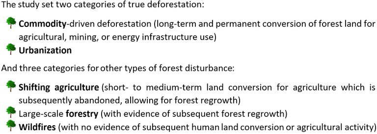
As explained in a paper published two weeks ago, the researchers had to first "train" the computer program with 5000 10 km by 10 km Google Earth images which had been already classified into five categories (see below). A validation sample of 1565 randomly selected images later showed their model to have an average accuracy of 89% when categorising new pictures (being as high as 94% for commodity-driven deforestation events).


The final analysis of the data showed that between 2001 and 2015 around 27% of all worldwide forest loss was due to commodity-driven deforestation, with activity shifting from Brazil to other countries in Latin America and Southeast Asia during the 15-year period. Urbanization claimed less than 1% of the total deforestation while shifting agriculture, wildfires and forestry averaged at around 23-26% each out of the total worldwide forest disturbance.
The researchers note that their study shows that commitments to reach zero-deforestation are not on track to reach their 2020 goals. By distinguishing between the different types of forest coverage loss, the new results allow policymakers to focus their efforts in the areas that will actually undergo long-term deforestation instead of more sustainable temporal losses. The study concludes that Latin America, Africa and Southeast Asia should be the focal points of corporations trying to eliminate deforestation from their supply chains and of policymakers looking to reduce greenhouse gas emissions.
Finally, I wanted to give a shout out to @treeplanter, who are fighting deforestation in Cameroon. I'm in no way associated with them, but they seem to be pretty transparent about their work and are fellow steemians to boot.
Original paper:
"Classifying drivers of global forest loss" at Science
Further reading and sources:
"A new map reveals the causes of forest loss worldwide" at ScienceNews
"Tracking corporate commitments to deforestation-free supply chains, 2017" at Forest Trends
"CO2 emissions from forest loss" at Nature Geoscience
"Reference: Deforestation" at National Geographic
You just planted 0.10 tree(s)!
Thanks to @tychoxi
We have planted already 3767.03 trees
out of 1,000,000
Let's save and restore Abongphen Highland Forest
in Cameroonian village Kedjom-Keku!
Plant trees with @treeplanter and get paid for it!
My Steem Power = 30727.44
Thanks a lot!
@martin.mikes coordinator of @kedjom-keku
This post has been voted on by the steemstem curation team and voting trail.
There is more to SteemSTEM than just writing posts, check here for some more tips on being a community member. You can also join our discord here to get to know the rest of the community!
😞
Yeah, pretty sad. Especially considering we have had the means and knowledge to engage in more sustainable practices for decades.
Greetings! I am a minnow exclusive bot that gives a 4X upvote! I recommend this amazing guide on how to be a steemit rockstar! I was made by @EarthNation to make Steemit easier and more rewarding for minnows.
As a follower of @followforupvotes this post has been randomly selected and upvoted! Enjoy your upvote and have a great day!