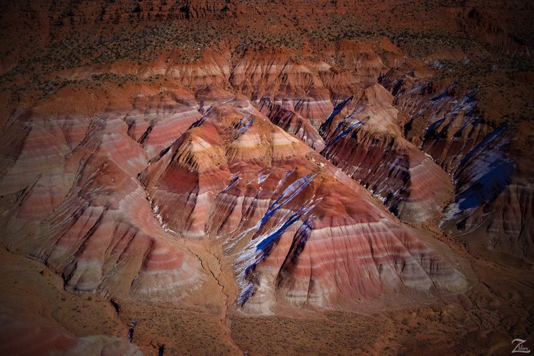
Crimson colored outcroppings across from Calico Peak on the Paria River in southern Utah. Paria /pəˈriːə/, (rhymes with "Maria") or Pahreah, is an old abandoned Mormon ghost town located alongside the Paria River in the Grand Staircase-Escalante National Monument in central Kane County, Utah, United States.
It was inhabited only a short time from 1870 to 1929, and later used as a filming location. The town was founded in 1865 by a Mormon group led by Peter Shirts. This early settlement was initially named Rockhouse, for Mr. Shirts's strongly built sandstone house.
After the end of the Black Hawk War in 1867 settlers began to arrive at a rapid pace. Farming produced good crops for several years, but irrigation was very difficult; each spring the surface runoff water was absorbed into the desert soil so rapidly after it fell that is was not available to properly water the fields.
In 1870 the residents agreed to move the settlement. They divided in two groups; half the people went about 5 miles (8.0 km) upstream and founded the town of Pahreah. Pahreah grew slowly throughout the 1870’s, and they build a general store, a church, a number of sandstone houses, and many log houses.
(Research Source)
The population grew to a whopping 47 families. Then the town was hit by hard times in the 1880’s. The Paria River extensively flooded every year from 1883 to 1888, washing away fields and even tearing down some buildings built too close to the riverside.
People started to move away when it became obvious this was a reoccurring issue. By 1892 there were only eight families left, but for some reason the US Government granted them a post office that year, under the name Paria. Not much changed until a very small gold mining operation was established here in 1911.
However within a year, that too had been destroyed by flooding. The post office finally was closed in 1914. A single lone bachelor prospector held out until 1929, then Paria was abandoned. The Paria River travels all the way from Bryce Canyon National Park to empty into the Colorado River in the Grand Canyon some 95 miles southeast. It drains a rugged and arid region northwest of the Colorado River, flowing through multiple roadless slot canyons along part of its course.
(Research Source)
It is formed in southern Utah, in southwestern Garfield County from several creeks that descend from the edge of the Paunsaugunt Plateau, meeting just north of Tropic. It flows southeast across Kane County and the Grand Staircase-Escalante National Monument. Along the Arizona state line, it descends through the Vermilion Cliffs in the Paria Canyon and onto the Paria Plateau.
(Research Source)
It joins the Colorado from the northwest approximately 5 mi (8 km) southwest of Page, Arizona and the Glen Canyon Dam. The lower 20 mi (32 km) of the river are within the Paria Canyon-Vermilion Cliffs Wilderness.
I lensed this image while flying, exploring and filming the area around the Grand Staircase-Escalante National Monument and surrounding wilderness. It was early spring hence the small amount of snow left on the formation.
This is from "Where Eagles Fly - The American Wilderness Expedition" my personal project of exploration in the North American Wilderness.
I'm on a mission to raise awareness of our Iconic Natural Heritage Treasures of North America. Please consider upvoting this and even re-steemit if you like what you see and want to help spread the word!
Yehaw!

Upvoted
Good story
So beautiful the perception you have on the Paria River in southern Utah. Hope more people would value more their native places (country). Upvoted and upfollowed.
Excellent historical background, and very nice pictures. Hard to believe that anyone would choose that location to try to start a settlement. Occurred before they had the tools to fly over and scout out the location it seems
STEEM On!!
Dave B
Please share your favorite camera to use with aerial photography?
@skypilot Colorful plateau with a very colorful history. Nicely written.