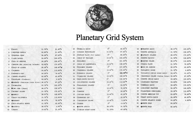
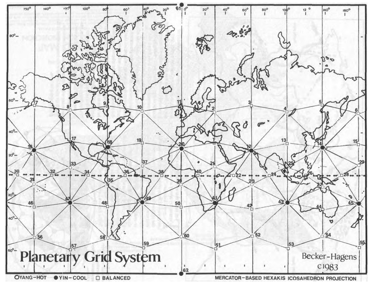
Becker-Hagens Planetary Grid System Coordinates
31.72°N 31.20°E On the Egyptian continental shelf,
in the Mediterranean Sea. at approximately the midpoint between
the two outlets of the Nile at
Masabb Rashid and Masabb
Dumyat52.62°N 31.20°E On the Sozh Rivereast of Gomel,
at the boundary junction of three
Soviet republics — Ukraine,
Bellorussia, and Russia58.28°N 67.20°E In marshy lowlands just west of
Tobolsk52.62°N 103.20°E In the lowlands north of the
southern tip of Lake Baykal, at
the edge of highlands58.28°N 139.20°E In the highlands along the coast
of the Sea of Okhotsk52.62°N 175.20°E Slightly east of Attu at the
western tip of the Aleutian Islands58.28°N 148.80°W Edge of continental shelf in the
Gulf of Alaska52.62°N 112.80°W Buffalo Lake, Alberta, at the edge
of highlands in lowlands58.28°N 76.80°W Just east of Port Harrison on Hudson's Bay
52.62°N 40.80°W Gibbs Fracture Zone
58.28°N 4.80°W Loch More on the west coast of
Scotland26.57°N 67.20°E On the edge of the Kirthar Range
bordering the Indus River Valley,
directly north of Karachi31.72°N 103.20°E At the east edge of the Himalayas
in Szechuan Province, just west
of the Jiuding Shan summit26.57°N 139.20°E At the intersection of Kydshu
Palau Ridge, the West Mariana
Ridge, and the Iwo Jima Ridge31.72°N 175.20°E At the intersection of Hess
Plateau, the Hawaiian Ridge, and
the Emperor Seamounts26.57°N 148.80°W Northeast of Hawaii, midway between the Murray Fracture Zone
and the Molokai Fracture Zone31.72°N 112.8O°W Cerro Cubabi, a highpoint just
south of the US/Mexico border
near Sonoita and lava fields26.57°N 76.80°W Edge of continental shelf near
Great Abaco Island in the
Bahamas31.72°N 40.80°W Atlantis Fracture Zone
26.57°N 4.80°W In El Eglab, a highland peninsula
at the edge of the Sahara Desert
sand dunes10.81°N 31.2O°E Sudan Highlands, at the edge of
White Nile marshfields0° 49.20°E Somali Abyssal Plain
10.81°S 67.20°E Vema Trench (in the Indian
Ocean) at the intersection of the
Mascarene Ridge, the Carlsberg
Ridge, and Maldive Ridge into
the Midlndian Ridge0° 85.20°E Ceylon Abyssal Plain
10.81°N 103.20°E Kompong Som. a natural bay on
the southern coast of Cambodia
southwest of Phnom Penh0° 121.20°E At the midpoint of Teluk,
Tomini, a bay in the northern area
of Sulawesi10.81°S 139.20°E Midpointof the mouth of the Gulf
of Carpentaria0° 157.20°E Center of the Solomon Plateau
10.81°N 175.20°E Midpoint of abyssal plain between Marshall Islands, MidPacific Mountains, and the
Magellan Plateau0° 166 80°W Nova Canton Trough
10.81°S 148.80°W Society Islands
0° 130.80°W Galapagos Fracture Zone
10.81°N 112.80°W East end of the Clipperton Fracture Zone
0° 94.80°W Junction of the Coeos Ridge and
the Carnegie Ridge, just west of
the Galapagos Islands.10.81°S 76.80°W Lake Punrrun in Peruvian coastal
highlands0° 58.80°W State of Amazonas. at tip of
minor watershed highlands10.81°N 40.80°W Vema Fracture Zone
0° 22.80°W Romanche Fracture Zone
10.81°S 4.80°W Edge of Mid-Atlantic Ridge in
Angola Basin, just southeast of
Ascension Fracture Zone0° 13.20°W Gabon highlands, at the intersection of three borders
26.57°S 31.20°E L'uyengo on the Usutu River in
Swaziland31.72°S 67.20°E Intersection of the Mid-Indian
Ridge with the Southwest Indian
Ridge26.57°S 103.20°E Tip of the Wallabi Plateau
31.72°S 139.20°E In a lowland area just east of St.
Mary Peak (highest point in the
area) and north east of Spencer
Gulf26.57°S 175.20°E At the edge of the Hebrides
Trench, just southwest of the Fiji Islands36.72°S 148.80°W Undifferentiated South Pacific
Ocean(!)26.57°S 112.80°W Easter Island Fracture Zone
31.72°S 76.80°W Nazca Plate
26.57°S 40.80°W In deep ocean, at edge of continental shelf, southeast of Rio de
Janeiro31.72°S 4.80°W Walvis Ridge
58.28°S 31.2O°E Enderby Abyssal Plain
52.62°S 67.20°E Kerguelen Plateau
58.28°S 103.20°E Ocean floor, midway between
Kerguelen Abyssal Plain and
Wilkes Abyssal Plain52.62°S 139.20°E Kangaroo Fracture Zone
58.28°S 175.20°E Edge of Scott Fracture Zone
52.62°S 148.80°W Udintsev Fracture Zone
58.28°S 112.80°W Eltanin Fracture Zone
52.62°S 76.80°W South American tip, at the edge
of the Haeckel Deep58.28°S 40.80°W South Sandwich Fracture Zone
52.62°S 4.80°W Boivet Fracture Zone
North Pole
South Pole
source: ANTI GRAVITY AND THE WORLD GRID BY DAVID HATCHER CHILDRESS
HUMAN DIAMAGNETISM GRAVITY ANTENNA LEVITATION
The principle of diamagnetism which underlies
human-induced levitation and anti-gravity vortexes on the
planet can be demonstrated simply in what I call the human
gravity antenna. Diamagnetism (explained below) is essentially
a magnetic-neutral zone existing between a north and south
magnetic field, which can be exploited for purposes of
levitation. As I will indicate below, there are many such
"magnetic flow reversal points" on the Earth marked by Grid
points.
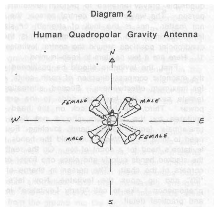
An arrangement of five human beings can be used as a
quadruple gravity antenna to perform levitation of the central
person. The weight of the central person, the levitatee, does
not matter nor is the lack of strength or size of the four
levitators important. What is important is the form of the
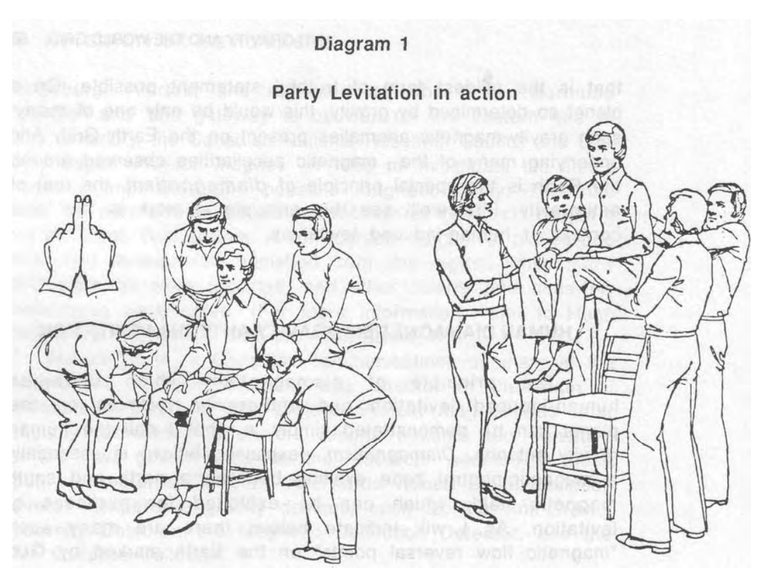
quadropolar positions around the central levitatee (See Diagram
1). Here are a few pointers to keep in mind.
First, the levitators should be positioned 45 degrees off
the magnetic compass direction of north, south, east, and west
for maximum effectiveness. Second, alternation of male and
female sex of the levitators adds to the gravity antenna's
power. Third, the hand stack on the head of the central
levitatee by the levitators should not have like-gendered
(male/male, female/female) hands touching. Fourth, there's no
need to think of anything—just hold the hands stacked on the
levitatee's head for a count of ten. On the tenth count remove
the stacked hands quickly and place one finger each on the four
corners of the chair. The person in charge of counting says
"lift" and up goes the levitatee. Now let's examine this
phenomenon I like to call "Party Levitation" in more specific
and practical detail.
To do Party Levitation you will need five people, one
to be levitated—henceforth to be called the levitatee— and
four to do the levitating—henceforth to be called the levitators.
The levitatee sits in a chair and the four levitators stand
around him so that they form a square. One levitator should
stand to the levitatee's left, and just behind his shoulder.
Another levitator should stand in front of him and to his left,
close to his left knee. The other two should stand on the right
side of the levitatee's body and in similar positions.
Now the object of Party Levitation is to make the
levitatee's body so light in weight that the four levitators can
lift him several feet into the air using a single finger each. If
the experiment is performed properly none of the levitators
will feel the slightest resistance to their efforts. It will be as
if the levitatee's body has lost its weight entirely.
While the levitatee is sitting, the four levitators
surround him in the manner indicated and place their hands, one
atop the other, on his head, as if they were healing him by the
laying on of hands.
The person who is going to float must sit relaxed in a
straightbacked chair with his legs together, his feet on the
floor, and his hands in his lap. The other four participants now
stand two on each side of the seated party, one at each shoulder
and one at the knee. Instruct all four to extend their arms and
place their closed fists together, closed except for the
forefingers which should be extended and touching each other
along their lengths as shown. The person nearest the seated
man's left shoulder is now asked to place his two extended
fingers, palms downwards, beneath his left armpit. Likewise,
his opposite number inserts his forefingers beneath the right
armpit, and again the other two respectively beneath the seated
man's knees.
Now invite the four assistants to lift the man in this
position, using only these extended fingers. However hard they
try, it is impossible. As soon as you have registered their
inability to do so, ask them to stack their hands alternately,
one on top of the other on the man's head, in such a way that no
person has his own two hands together, and then to exert a
steady pressure downwards. As they keep this up you count to
ten. On the count "nine", they must withdraw their hands
quickly from his head and resume their earlier positions with
their extended forefingers. On the count of "ten" they must try
again to lift the man with those fingers alone. This time he
will go soaring into the air with no difficulty whatsoever.
source: ANTI GRAVITY AND THE WORLD GRID BY DAVID HATCHER CHILDRESS PAGE 55-57