If you have been following my blog, then you’ll know that this week I have been discussing peculiar geological features from around the world. The example that I’ll be using in todays post will be my final excursion here on Earth and then it’s off to the cosmos! Through my research to identify “oddball geological features,” one thing has become abundantly clear– we know very little about our planet and solar system. That’s not to discredit the hard work and observations scientists have made for the better part of 2000 years. I’m simply conveying that in the grand scheme of things, we have much more to learn. It is my hope, that through my writing I will be able to inspire some of you to consider carrying out the human inhibition and to a certain extent, tradition, to simply ask question, “why?” With that being said, today we’ll be discussing the Zhangye Danxia Landform in the Gansu Province of China– more commonly called the Rainbow Mountains by westerners.
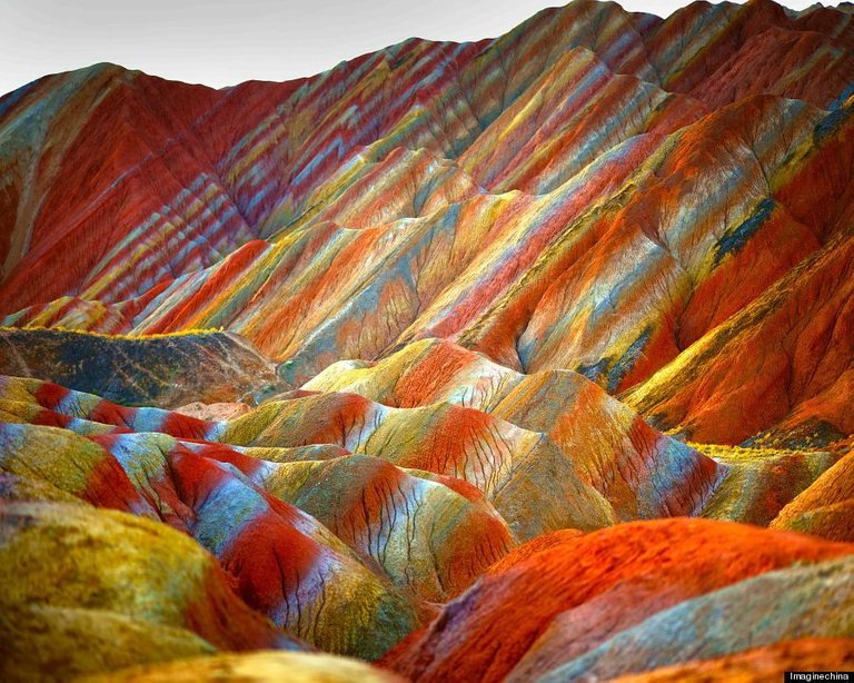
 Figure 1. This amazing photos shows the colorful layers of the Rainbow Mountains in China. While this photo may look enhanced, it isn't. These vivid colors are more pronounced when the region is saturated by rainfall, which is the case in this photo. [Image Source]
Admittedly, these rainbow technicolor mountains– that appear to be from a trippy Simpson’s episode– were fairly difficult to research. This is largely due to the lack of scholarly articles on the feature itself. I suppose from a geological point of view the formation of the Zhangye Danxia Landform is somewhat of a banal subject, which I will explain in a bit. However, I still find it strange that something so beautiful wouldn’t be considered a great entry point and example to inspire the next potential geologist in the world. They are truly something to be in awe over.
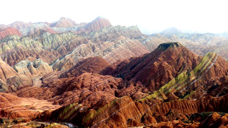
 Figure 2. This is what the appearance of the Rainbow Mountains typically look like without water saturating them. [Image Source]
When first looking at the images of the Rainbow Mountains, I assumed the colors must have been saturated by means of Photoshop. In some instances this was true, but upon further investigation, it would seem most of the photos are unedited. If you’ve read the description below the photos I have shared above, you’ll see that it's rain that actually draws out the vivid contrast of colors. In Fig. 1, this is what the mountains look like after being saturated by rain. In Fig. 2, they are still impressive, but visually are bit more lackluster in comparison.
So how did they form? Though the information at hand was limited, knowledge that I have retained through my studies and the articles that I have procured, I was able to come to a conclusion. The topography of the Rainbow Mountains are the product of the deposition of sediments (sedimentation) that occurred over eons and plate tectonics.
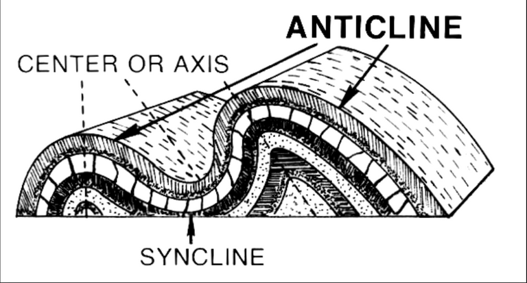
 This diagram displays the distortion of rock layers, which occurs due to plate tectonics (compression) in the region. Overtime, these layers can be exposed by erosion due to weathering. It would appear this is exactly what took place at the Zhangye Danxia Landform.
Given the location of the Danxia formations, it is clear the tectonic plate stresses that created the Himalayan Mountains (i.e. convergent plate boundary), caused the once horizontal sedimentary layers to be folded and thrusted over time. This can be identified by the anticline and syncline of the technicolor layers. The graph above should help give you a better understanding of how to identify the anticline and syncline of a rock face. After being distorted from plate tectonics, weathering (e.g. wind, rain) slowly carved out the valleys, crevasses and cliffs in the region, exposing the layers of rock. It should be noted, that similar examples of this type of geological feature can be seen in Peru and British Columbia, Canada. However, it would appear the colors in those examples aren't nearly as vivid.
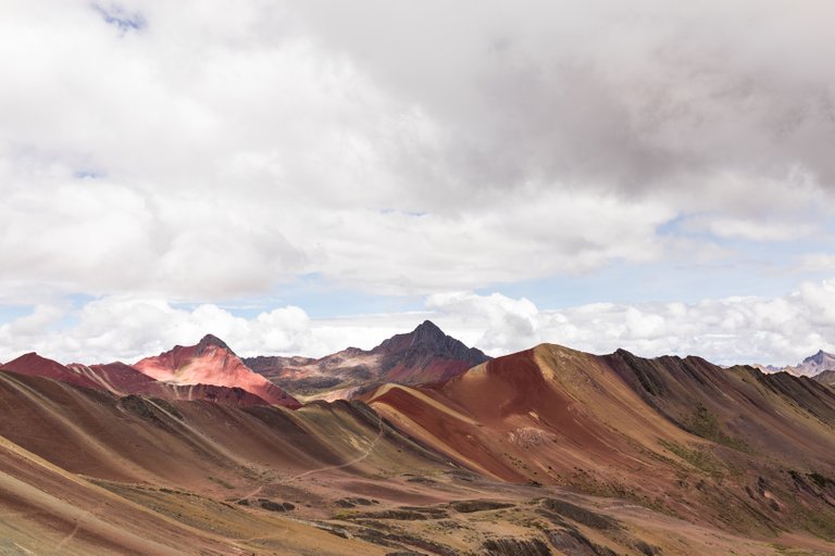
 In Peru, the Cusco Rainbow Mountains are very similar to the mountains of Zhangye Danxia formation. Clearly, they aren't nearly as flamboyant. [Image Source]
As for the color of the layers themselves, this can be explained through paleoclimatology. At the time of deposition of the sediments, it is clear that the climates in which they were created, changed drastically over a very long period of time (millions of years). The biggest tell that this is the case, are the bluish-greenish-gray layers. This typically indicates that there was some sort of organic plant matter at the time of deposition or it contains a mineral called glauconite, which is found in marine environments. As for the red and and yellow colored layers, the red indicates the presence of the iron-rich mineral hematite, which oxidizes (i.e. rusts). This could have occurred at the time of the rock formation or when the layers were exposed to the atmosphere. The yellow indicates the presence of sand and clay, leading me to believe it was an arid climate at the time of deposition.
All science-y stuff set aside, I think it goes without saying that the Rainbow Mountains of China fall under the classification of “oddball geological features.” The more of these examples I curate, the more I come down with the travel bug. Maybe after I’m finished with school, my blog will help fund that adventure. If you missed the previous two posts in this series and enjoyed this article, please check them out. They discuss the Sailing Stones of the Playa and the Chocolate Hills of Bohol. If you contribute to the subjects dealing with earth sciences here on Steemit, be sure to check out Geopolis and join the Discord channel!
Bibliography:
https://en.wikipedia.org/wiki/Zhangye_National_Geopark
http://www.educationworld.com/a_lesson/lesson-plan-booster/china-zhangye-danxia-geology.shtml
https://www.geologyin.com/2015/09/rainbow-mountains-in-chinas-danxia.html
https://en.wikipedia.org/wiki/Sedimentary_rock
https://en.wikipedia.org/wiki/Hematite
https://en.wikipedia.org/wiki/Glauconite
https://en.wikipedia.org/wiki/Paleoclimatology
https://en.wikipedia.org/wiki/Syncline
Classroom studies and casual reading.
Your post has been personally reviewed and was considered to be a well written high quality article!
You received a 50% upvote since you are not yet a member of geopolis.
To read more about us and what we do, click here.
If you do not want us to upvote and comment on your posts concerning earth and earth sciences, please reply stop to this comment and we will no longer bother you with our love ❤️ https://steemit.com/introduceyourself/@geopolis/introducing-geopolis-the-community-for-global-sciences
Incredible Geology! You'll have to come see ours, in Oregon, when you can. They are the John Day Fossil Beds! Steem On!
Yeah, I can't wait to head up north. I've actually been considering living in Astoria for a short amount of time and go on some adventures!
Beautiful pictures, and great explanation of the geological features. Look forward to reading more of your posts!
Thanks a bunch! I'm glad you enjoyed the post. I'm going to attempt to make a post everyday. This means I'll probably be doing posts in a similar fashion as this one. For the sake of keeping things organized.
@originalworks
Overall I think this is a nice article and it is well written. Great to see people are interested in geology here on steemit! I do have a few remarks though:
You wrote sedimentation occured over Eons and plate tectonics. An article I found that deals with this topic (Geologic origins of danxia and colorful hills of Zhangye and comparison with danxia landform in southern China) suggests the strata was deposited between 140 - 100 Ma, which was during the (Early) Cretaceous Period.
The geological time-scale is divided into the Hadean, Archean, Proterozoic and Phanerozoic Eons. These Eons are divided into eras, which are in turn divided into periods, epochs and ages. What I'm trying to say is that with the word eons you suggest that these layers have been deposited over a very long time, although they were only deposited during a 'short' time in the Cretaceous Period.
Secondly, sedimentation and the tectonics you refer to later in the article (convergence, folding and thrusting), usually don't go hand in hand. Sedimentation occurs usually in basins as a result of extension and thrusting usually results in erosion of sediments. The fact that the layers seem to lie concordant on top of each other suggests they were first deposited horizontally and after that they were tilted.
This brings me to the part where you write "the once horizontal sedimentary layers were folded and thrusted". If you take a look at your second figure you see that the layers all seem to dip in the same direction. If these rocks were folded then the layers would also change dip. My guess is that these rocks were uplifted and tilted and the morphology is formed by weathering, as you explain nicely.
Many different colours usually indicate to lacustrine deposits. Depending on the conditions in the provenance area, rivers can transport anything from gravel to clay particles and therefore could deposit sediments with very differing colours. The paper I mentioned above suggests the colours depend on the redox state of the rock. Large Fe3+ contents result in red colours and large Fe2+ contents usually result in white and black colours. Oxidative conditions usually indicate terrestrial deposits and reductive conditions indicate marine (anoxic) conditions. Hematite is indeed an iron-bearing mineral, but it doesn't oxidize; it is already oxidized. Organic matter found in rocks is usually black, not blueish-greenish-gray. Clays usually give sedimentary rocks these colours.
Furthermore, Diagenesis could play a big role in giving these strata their colours (think of groundwater. It can dissolve elements, transport them and precipitate them elsewhere, giving the strata a different colour. Many of the transition metals have strong vivid colours).
I hope you don't feel attacked by my post. On the contrary, I hope you see it as constructive criticism. I think what you're doing is great and so upvoted you;) Keep it coming!
The Rainbow Mountains, located in China’s Zhangye Danxia Landform Geological Park are considered one of the geological wonders of the world. These mountains take their colors from the colorful rock formations and are a major tourist destination. This site was named a UNESCO World Heritage Site.
Normally, no one would think of any mountains to take such amazing colors but the Quran mentions the existence of colorful mountains as one of Allah’s creations. Here is the verse of the Quran.
( Have you not seen that Allah sends down water from the sky? With it We produce fruits of various colors. And in the mountains are streaks of white and red — varying in their hue — and pitch-black. Likewise, human beings, animals, and livestock come in various colors. From among His servants, the learned fear Allah. Allah is Almighty, Oft-Forgiving )
The Quran 35:27–28
via https://medium.com/@Marytn/chinas-rainbow-colored-mountains-zhangye-danxia-landform-geological-park-201017eb9c74