This time I have a new challenge for you in the competition.
Take pictures of the city you live in and tell about the place and the country.
Stories without images are not rewarded.
This picture is from my home town Fredrikstad in Norway. You see the river that goes through our city called "Glomma"
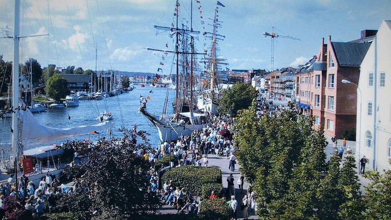
Glomma or Glåma is the longest river in Norway with a length of 604 km long. It's a meander river. The river has its headland in Aursunden north of Røros and flows into the Oslo fjord at Fredrikstad. Glomma is the mainland in the waterway with the same name, which has a total drainage area of 42 441 km² (422 km² in Sweden).
You can read more from my previous post from Fredrikstad here
For now you are going to take pictures and tell about the city and country where you live in
Upload your pictures and story in the comment here and write that you are in contest "home town" To participate, you must also Re-steemed and upvote this contest and write that you have done it.
I want to give good upvote to those who contribute to great stories with pictures
Simple and repeated comments do not get upvote from me. A good comment as content more a few words can be upvote.
This will be a small competition where the best can get up to 50 % upvote.
If you wish, you can also use your story on your own blog as well as the one you post here. Remember to write that you are in competition for @xpilar "home town" So there will not be Spam / plagiarists.
Simple rules as follows: pictures drawings, paintings taken from the web or the media you are not allowed to use, then you must prove that you own it, otherwise no upvot from @pilar
If you use images and information from the web, you need to indicate where it comes from example type "search image credit" or where info is taken from
* Spam plagiarists may be flagged 
In the competition, only one post per participant is allowed

Ilustrated images in this post are credited to Pixabay.com
Re-steemed and upvote this post and write that you have done it in the comments box to be in the competition.
Competition runs in. 4 days before it ends
What are you waiting for, come on, have fun

Entry "Home Town" Competition.
Delhi: Hindustani pronunciation: [d̪ɪlliː] Dilli, officially the National Capital Territory of Delhi or NCT, is a city and a union territory of India. It is bordered by Haryana on three sides and by Uttar Pradesh to the east. The NCT covers an area of 1,484 square kilometres (573 sq mi). According to 2011 census, Delhi's city proper population was over 11 million, the second highest in India after Mumbai, while the whole NCT's population was about 16.8 million. Delhi's urban area is now considered to extend beyond the NCT boundary to include an estimated population of over 26 million people making it the world's second largest urban area. As of 2016 recent estimates of the metro economy of its urban area have ranked Delhi either the top or second most productive metro area of India. Delhi is the second wealthiest city after Mumbai in India, with a total wealth of $450 billion and home to 18 billionaires and 23,000 millionaires.
Delhi has been continuously inhabited since the 6th century BC.Through most of its history, Delhi has served as a capital of various kingdoms and empires. It has been captured, ransacked and rebuilt several times, particularly during the medieval period, and modern Delhi is a cluster of a number of cities spread across the metropolitan region. A union territory, the political administration of the NCT of Delhi today more closely resembles that of a state of India, with its own legislature, high court and an executive council of ministers headed by a Chief Minister. New Delhi is jointly administered by the federal government of India and the local government of Delhi, and is the capital of the NCT of Delhi. Delhi hosted the first and ninth Asian Games in 1951 and 1982 respectively, 1983 NAM Summit, 2010 Men's Hockey World Cup, 2010 Commonwealth Games, 2012 BRICS Summit and was one of the major host cities of the 2011 Cricket World Cup. Delhi is also the centre of the National Capital Region (NCR), which is a unique 'interstate regional planning' area created by the National Capital Region Planning Board Act of 1985.
Delhi's culture has been influenced by its lengthy history and historic association as the capital of India, Although a strong Punjabi Influence can be seen in language, Dress and Cuisine brought by the large number of refugees who came following the partition in 1947 the recent migration from other parts of India has made it a melting pot. This is exemplified by many significant monuments in the city. Delhi is also identified as the location of Indraprastha, the ancient capital of the Pandavas. The Archaeological Survey of India recognises 1200 heritage buildings and 175 monuments as national heritage sites. In the Old City, the Mughals and the Turkic rulers constructed several architecturally significant buildings, such as the Jama Masjid – India's largest mosque built in 1656 and the Red Fort. Three World Heritage Sites – the Red Fort, Qutab Minar and Humayun's Tomb – are located in Delhi. Other monuments include the India Gate, the Jantar Mantar – an 18th-century astronomical observatory – and the Purana Qila – a 16th-century fortress. The Laxminarayan temple, Akshardham temple,Bangla Sahib the Bahá'í Lotus temple and the ISKCON temple are examples of modern architecture. Raj Ghat and associated memorials houses memorials of Mahatma Gandhi and other notable personalities. New Delhi houses several government buildings and official residences reminiscent of British colonial architecture, including the Rashtrapati Bhavan, the Secretariat, Rajpath, the Parliament of India and Vijay Chowk. Safdarjung's Tomb is an example of the Mughal gardens style. Some regal havelis (palatial residences) are in the Old City.
Thanks @xpilar
Rules observed:
Re-Steemed and upvoted
Good pictures and very good information @aabidemi
Hi @aabidemi very good information of your post
(like the pronounce of delhi like my name)

Regard from Aceh, Indonesia
Re-steemed
Ejigbo is a prominent town in Yoruba Land and the headquarters of Ejigbo Local Government Area, one of the oldest local government areas of Osun State in Nigeria. Ejigbo is strategically placed in the middle of the region, as 35 kilometres (22 mi) north-east of Iwo, 30 km (19 mi) from Ogbomoso in the north and 24 km (15 mi) from Ede in the south-east. It is about 40 km (25 mi) north-west of Osogbo, the capital of Osun State, and about 95 km (59 mi) north-east of Ibadan. It is part of the Ede North/Ede South/Egbedore/Ejigbo federal constituency. The population is 138,357 according to the GeoNames geographical database. The average elevation is 426 metres (1,398 ft).
It has an area of 373 square kilometres (144 sq mi) and had a population of 132,641 at the 2006 census. The average annual rainfall is 52.35 inches (1,330 mm), though there are great deviations from this mean value from year to year. Usually, the rainy season lasts from April to October.
Brief history of Ejigbo
Akinjole Ogiyan, The founder of Ejigbo Land
Ejigbo is a major Yoruba town in Osun State of Nigeria. It is about 40 kilometres (25 mi) to Oshogbo, the capital of Osun State.
According to oral history, Ejigbo is an ancient settlement. It was founded by Akinjole Ogiyan (abbreviation of "Ogiriniyan"), right after the old Oyo. Ogiyan has a rich pedigree, as a descendant of Oduduwa and the ruling family of Ile-Ife. Together with his brothers, particularly the Akire, the founder of Ikire-Ile, left Ile life with Oranya (Oranmiyan) – the founder of old Oyo, to establish their own town. The fact that the Ogiyan is from Ile-Ife, is confirmed by "Ejigbo Mekun" the name of a market in Ile-Ife. Akinjole settled many other villages spread around Yorubaland. He was the paramount ruler and prescribed authority over many if not all of them. The following towns and villages, among others, were under him: Ika, Igbon, Olosinmo, Ologede, Inisa, Aato, Ijimoba, Afake, Ilawo, Inisa Edoro, Isundunrin, Olla, Ado Ori-Oke, Ayegunle, Idigba, Ibogunde, Songbe, Olorin, Osuntedo and Iwata.
Around 1835, Ejigbo came under Ibadan, when the Ibadan army moved to protect Osogbo from Ilorin invaders. In fact, detachments from Ejigbo assisted the Ibadan army in the Osogbo, Ijaye, Jalumi, Off, and Kiriji wars between 1840 and 1866. Ajayi Ogboriefon, Balogun and leader of the Ibadan army in the Jalumi war circa 1860 and 1878 was native of Ejigbo from the Akala compound. His mother, Alagbabi, was the daughter of an Ogiyan of Ejigbo. In 1934, when the then government returned to the terms of the 1893 Treaty, which recognized Ibadan's independence and gazettes of the Baale and Divisional Council of Ibadan as an Independent Native Authority, five district obas, including the Ogiyan, were made members of the divisional Council.
The Ogiyan and council were also gazetted as subordinated to Native Authority under Ibadan for Ejigbo District Council. Although changes were made enlarging the membership of the Council between 1937 and 1938, the five districts Obas that included the Ogiyan retained their membership of the said Divisional Native Authority.
Thanks for reading.
@xpilar and everyone.
Good pictures and very good information @willy1
love the history and Very cultural place, voted

Kayangan peak is the top tourist attraction of the hills in the southern coastal area of Bantul regency. Its existence is still rarely known for being a tourist attraction trapper from Goa Pundong Japan. This peak has almost the same viewing angle with Bukit Parangndog located in the southeast of this hill.
Puncak Kayangan is located in the hamlet of Ngreco, Seloharjo village, Pundong district, Bantul district, DI Yogyakarta.

Location Puncak Kayangan Pundong located in the hilly area is still one area with the Pundong Japanese Cave. The route to this place from downtown Yogyakarta to the south passes Jalan Parangtritis. Push into Parangtritis Street until across the Opak River Bridge adjacent to the entrance of Parangtritis Beach entrance fee. Once out of the bridge immediately turn left towards the alternative path Parangtritis-Siluk. Follow the directions board to Goa Pundong where one access road with Sendang Surocolo and Goa Sunan Mas. Entering the area of Goa Pundong Japan follow the asphalt road through the highest cave area that has gasebo view and meet the signpost directions to Puncak Kayangan. Vehicles can be parked by the road and then walk 50 meters to reach the peak area.
Amazing Indonesia voted
Great pictures and information @jroh
in my home town there is the very beautiful place, yeah his name is Kawah Putih. Kawah Putih is a tourist place located at Jalan Raya Soreang - Ciwidey KM 25, Bandung Regency, West Java Province Indonesia.
The location if accessed from the direction of the city of Bandung is 35 KM, with a driving time of about 2.5 hours.
Ciwidey White Crater is now becoming has become the most popular tourist attractions in southern Bandung, and at the same time become Ikon tourist area Ciwidey.
Currently the management of White Crater is done by Perhutani of West Java, and it has been done since 1987.
This place is always busy visited by tourists at home and abroad, especially during the holiday weekend and will be more crowded in the long holiday season such as holidays and new year.
nice @hitz
Luar biasa bandung, Keep it up
White crater is the one of my favorit and thats was awesome place.
Great pictures and information
Aceh Utara District
(Aceh: Acèh Barôh, Jawi: اچيه باروح) is a district located in the province of Aceh, Indonesia.

The district's capital was moved from Lhokseumawe to Lhoksukon, following Lhokseumawe as an autonomous city.
This district is classified as the largest industrial area in the province and is also classified as the largest industry outside Java, especially with the opening of liquefied natural gas processing industry PT. Arun LNG in Lhokseumawe in 1974. In this area there are also other big factories: Kraft Aceh Paper Factory, AAF Fertilizer (Aceh Asean Fertilizer) factory and Iskandar Muda Pupuk factory (PIM).


In the agricultural sector, this region has its own reputable reputation as a very important rice producer. then as a whole the District of North Aceh is the most potential Level II region in the province and per capita income above paras Rp. 1.4 million without oil / gas or Rp. 6 million with oil and gas.
Oil and gas fields were discovered in Lhokseumawe, the capital of North Aceh around the 1970s. Then, Acehpun began to be visited by foreign investors who are interested in the great natural resources. Since then, liquefied natural gas or Liquefied Natural Gas (LNG) processed at PT. Arun Natural Gas Liquefaction (NGL) Co., which comes from the installation of ExxonMobil Oil Indonesia Inc. (EMOI) in the Lhokseumawe industrial zone, has transformed the region into a modern petrochemical industry.
Economic activity of North Aceh Regency is dominated by two sectors, namely mining and quarrying sector, and manufacturing industry sector. In the mining sector, gas wells processed by PT. EMOI is certainly one of the advantages of this sector. With a contribution of Rp 8.6 trillion in Gross Regional Domestic Product (PDRB) in 2000, he was ranked first followed by the industry sector of Rp 4.7 trillion.
In the field of religion, the people of Aceh Utara are religiously devout Muslims. In 1994, there were 782 people who went on the pilgrimage.
North Aceh now occupies the former territory of the Islamic Kingdom of Pasai Ocean. Pasai Sultanate according to some opinions mentioned as the first kingdom to adopt the system of Islamic governance in the archipelago. The Pasai Sultanate experienced approximately 300 years of glorious period until the arrival of the European explorer who subjugated the sultanate to almost nothing. Just a little of the history of the greatness of the Sultanate of Pasai that we still encounter today. The most prominent site of Pasai Ocean history is the complex of the tomb of Sultan Malikussaleh and the Tomb of Sultanah Nahrasiyah located in the coastal subdistrict of Samudera now. In the past, often historical artifacts in the form of gold coins found hidden in the ground on the former capital of the ancient Pasai Empire, but now this discovery is rare. When the Dutch invaded Aceh and succeeded in establishing a colonial government in 1904, Aceh Utara was designated an Afdeeling District led by the Resident Assistant. This vast territory is named Afdeeling Noord Kust Van Aceh (North Aceh District). Afdeeling is divided into 3 onderafdeeling (Kewedanaan) headed by a Countroleur (Wedana) namely: Onder Afdeeling Bireuen, Onder Afdeeling Lhokseumawe and Onder Afdeeling Lhoksukon. Besides, the Dutch East Indies government also set some Ulee Balang Regional Power which has self-government to the region and its people. This region is named as Zelf Bestuur In addition to Onder Afdeeling in North Aceh there are also some Ulee Balang Area (Zelf Bestuur) which has the right to govern itself against the area and its people are Ulee Balang Keureutoe, Geureugok, Jeumpa, and Peusangan each Zelf Bestuur is led by Ampon Chik.
After the independence period of Aceh Utara government territory was maintained in the territory once established by the Dutch. Based on Law No. 1 of 1957 and Presidential Decree No. 6 of 1959. The District of North Aceh Level II is divided into 3 (three) Kewedanaan namely: Kewedanaan Bireuen consists of 7 districts, Kewedanan Lhokseumawe consists of 8 Subdistricts, Luckking Lhoksukon consists of 8 districts .
Along with the development and growth of the region, population growth and the spirit of regional autonomy in 1999 on the former Bireun kewedanaan set to Bireuen District and in 2001 Lhokseumawe City following the new municipality out of North Aceh regency.
thank you ferry much
Wah wah wah, Againt from Aceh, Indonesia nice one
Thank you for very good information and a great picture @smeet
Banda Aceh
banda aceh as the capital of the Sultanate of Aceh Darussalam stood in the 14th century. The Sultanate of Aceh Darussalam was built on the ruins of previously existing Hindu and Buddhist kingdoms, such as the Indra Purba Kingdom, Indra Purwa Kingdom, Indra Patra Kingdom, Indrapuri Kingdom (Indrapuri). From the tomb of Sultan Firman Syah, one of the sultans who once ruled the Sultanate of Aceh, obtained information that the Sultanate of Aceh is capitalized in Kutaraja (Banda Aceh). (H. Mohammad Said a, 1981: 157).
The emergence of the Sultanate of Aceh Darussalam which capitalized in Banda Aceh can not be separated from the existence of the Lamuri Islamic Kingdom. At the end of the 15th century, with the establishment of a good relationship with the neighboring kingdom, the center of the throne of the Lamuri Kingdom was moved to Meukuta Alam. [1] The location of the Meukuta Alam palace is in the Banda Aceh region.
Sultan Ali Mughayat Shah ruled the Sultanate of Aceh Darussalam which capitalized in Banda Aceh, only for 10 years. According to an inscription found from the tomb of Sultan Ali Mughayat Syah, the first leader of the Sultanate of Aceh Darussalam died at 12 Dhul-Hijjah Year 936 Hijri or coinciding with August 7, 1530 AD. Although the reign of Sultan Mughayat Syah is relatively short, but he managed to build Banda Aceh as the center of Islamic civilization in Southeast Asia. At this time, Banda Aceh has evolved into one of the city's central defense that secured the maritime trade routes and the traffic of pilgrims from piracy by the Portuguese fleet.
At the time of Sultan Iskandar Muda, Banda Aceh grew back as a maritime trading center, especially for pepper commodities which at that time was very high demand from Europe. Iskandar Muda made Banda Aceh a world park, starting from the palace complex. The palace complex of the Sultanate of Aceh is also named Darud Dunya (World Park).
During the second Dutch aggression, there was a massive evacuation of Aceh troops out of Banda Aceh which was later celebrated by Van Swieten by proclaiming the fall of the sultanate of Aceh and changing the name of Banda Aceh to Kuta King. After entering the banner of the Government of the new Republic of Indonesia since December 28, 1962 the name of this city was again changed to Banda Aceh based on the Decree of the Minister of Public Administration and Regional Autonomy dated May 9, 1963. Dec 52/1 / 43-43
On December 26, 2004, the city was hit by a tsunami tidal wave caused by the 9.2 Richter scale earthquake in the Indonesian Ocean. This disaster swallowed hundreds of thousands of people and destroyed more than 60% of the city's buildings. Based on statistical data released by Banda Aceh City Government, the population of Banda Aceh City until the end of May 2012
thank my senior @xpilar
Hy @mnur, You do good job to write many information from our province, Proud of your work, Keep it Up
Amazing picture, thanks for the good information @ mnur
thank
Re-Steemed and upvoted.
Thank @xpilar to bring this competition.
I'm in the contest : "Home Town"
Lagos popularly known as EKO is a city in the Nigerian state of the same name. The city, with its adjoining conurbation, is the largest in Nigeria, as well as on the African continent. It is one of the fastest growing in the world,and also one of the most populous urban agglomerations. Lagos is a major financial centre in Africa; the megacity has the highest GDP, and also houses one of the largest and busiest ports on the continent.
Lagos initially emerged as a port city which originated on a collection of islands, which are contained in the present day Local Government Areas (LGAs) of Lagos Island, Eti-Osa, Amuwo-Odofin and Apapa; the islands are separated by creeks, fringing the southwest mouth of Lagos Lagoon, while protected from the Atlantic Ocean by barrier islands and long sand spits such as Bar Beach, which stretch up to 100 km (60 mi) east and west of the mouth. Due to rapid urbanization, the city expanded to the west of the lagoon to include areas in the present day Lagos Mainland, Ajeromi-Ifelodun and Surulere. This led to the classification of Lagos into two main areas - the Island, which was the initial city of Lagos, before it expanded into the area known as the Mainland.
Lagos, the capital of Nigeria since its amalgamation in 1914, went on to become the capital of Lagos State after its creation. However, the state capital was later moved to Ikeja in 1976, while the federal capital also moved to Abuja in 1991. Even though Lagos is still widely referred to as a city, the present day Lagos, also known as "Metropolitan Lagos", and officially as "Lagos Metropolitan Area is an urban agglomeration or conurbation.
The exact population of Metropolitan Lagos is disputed. In the 2006 federal census data, the conurbation had a population of about 8 million people. However, the figure was disputed by the Lagos State Government, which later released its own population data, putting the population of Lagos Metropolitan Area at approximately 16 million. As at 2015, unofficial figures put the population of "Greater Metropolitan Lagos", which includes, Lagos and its surrounding metro area, extending as far as into Ogun State, at approximately 21 million
Thanks for reading.
............................................................................
Welcome to Lagos City, Nigeria
The reach of Africa.
Imagecredit
Amazing picture, thanks for the good information @dabbey
nice @dabbey
followed you @dabbey and voted, Are you in the same town with @davidad so? Lagos in Nigeria metropolis town today I see
Yes we are from same city.. thx for your kind comments...
Naringgul, is a border area that lies between the boundary of Cianjur regency with Bandung regency. Here you will be satisfied because this place fits really is called the "Hidden Paradise" why is that?
The temperature in this area is about 25 ° C. Quite cool and need a pretty thick clothes also loh just not lose the same temperature in korea.
Naringgul District is the youngest area in Kab. Cianjur, consists of 11 villages. You must have heard about this area. Located on a plateau, with the air still very cool and awake to asriannya. How not cool, Naringgul is surrounded by forests that are protected and protected by Perum Perhutani.
Not only the parties perhutani course, local villagers too concerned about the population of living things that live on the forest (animals and plants). Naringgul has many forests such as wangun forest, cinerang forest, naringgul forest and malati forest.
If you want to survey the region do your research do not miss this one area :) this area is not sehoror imagine people out there anyway, maybe it's just their hoax hehehe
Next, for you who like hunting, selfie, adventure, nature lovers, and so you guys should come this place for eye wash:
Curug kettle (waterfall kettle)
letaknya not far from the settlement really strategic, you will not be hard to find this place, because of the highway guys :)
Sasak hanging ( suspension bridge)
For this place, bother easy datenginnya because you must pass a trip that is not easy, the form of a steep road becomes a challenge.
Statue stone site
there is in the village of balegede, precisely in Kampung miduana, the hours are quite far away and the track is enough to make heart dag dig dug ser hahaha
But gauhu deh ga if you've stopped there.
Well, that's one place that can try datengin kalo again in Naringgul and many more other places. Do not hesitate to ask yes, calm the people friendly :)
If you want to mantai (the current language which means go to the beach) you can ride cie mantai trip to Jayanti Beach located in the district cidaun, located 10-15 km from District Naringgul .
So long ago the information review of mimin, oh yes if you hobby or maybe have a motorcycle trail club, you should try to fight to this area.
Very natural picture, voted
Great pictures and information @putra-rahmat
This picture is from my home town Assam,India. This is the river Barak. It flows through three states Assam, Manipur and Mizoram. Its one of the river in Assam with a length of 564km.
Upvoted and Resteemed
It is looking very beautiful there, is enough cozy place to stay @iamhaque @iamhaque
fantastis
Thanks @baroen96
Yes there is. And thank you so much
you're welcome @iamhaque
Do you ever go fishing there ? Looks like big catfish water.
No i don't,but my neighbors do
I'd be interested to know what they catch, if you ever got the chance to ask. Or a pic! :)
Hy @iamhaque, for the first I followed you brader, You have good picture in your home town
Story from my Home town..
Sipiso-piso Waterfall is one of the tourist attractions in Sumatra Island. Located in Karo District, North Sumatra, which is not so far from the settlement of Tongging Village residents. This waterfall is located in the hills with an altitude of about 800 mdpl and surrounded by pine forests. Management of natural attractions waterfall is held by the District Government Karo. With a height of about 120 meters, Sipiso-piso Waterfall is one of the highest waterfalls in Indonesia. With this waterfall, Karo District became one of the most popular tourist attractions by domestic and foreign tourists.
You will be amazed by the charm of Sipiso-piso Waterfall, when you are in Tongging Village, the place where this waterfall is located. Before you see this waterfall up close, visit the viewing post located on the top of the hill. You will see the expanse of the beauty of Tanah Karo. From this viewpoint also, you can enjoy the beauty of Samosir Island, the island in the middle of Lake Toba.
Once you are happy to enjoy the beautiful scenery from afar, you can continue the journey through the ridge to mingle with the beauty of Sipiso-piso Waterfall. However, you do not have to worry in tracing the ridge, because it has provided a ladder path and is provided for the tourists. The journey takes about 1 hour to reach the base of this waterfall. In the journey, do not forget to capture this beautiful moment by taking pictures with the background of Lake Toba.

At arrival at the base of the waterfall, point your view to the hills around the waterfall. With the green blend of lush pine trees and the sound of waterfalls, make your mood and mind feel peaceful and serene. Do not forget to bring food to enjoy with your family after tired of playing water at Sipiso-piso Waterfall.
Sipiso-piso is does mean knife ?
But very beatiful waterfall and never gone
Great pictures and information @ummi
one of my favorite places in my home town, Ubud is named.
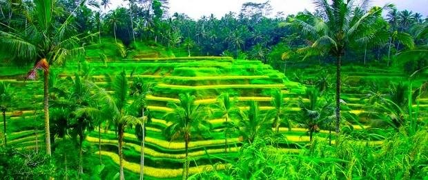
Ubud is one of the districts located in Gianyar regency, Bali. Tourist attractions in Ubud Bali already famous in the western hemisphere since the 1930's loh guys. Tourist attractions ubud famous for its location which is located very strategically between the rice fields and forests and the mountain ravines that make Ubud nature so beautiful.
HomepageTravel
Aulia Ritonga in Tours
Here are 14 Tourist Places in Ubud Bali The Most Expensive Travelers World
Ubud is one of the districts located in Gianyar regency, Bali. Tourist attractions in Ubud Bali already famous in the western hemisphere since the 1930's loh guys. Tourist attractions ubud famous for its location which is located very strategically between the rice fields and forests and the mountain ravines that make Ubud nature so beautiful.
You who want to visit Bali should stop by Ubud guys, besides enjoying the beauty of culture and tourism, here is also very suitable for you who want to find an atmosphere of tranquility. The people who live in the tourist attractions in Ubud Bali live harmoniously and their pulse comes from the arts and culture that has been attached since the first loh. Do not be surprised, if you stop by here you will find many galleries - art galleries, art performances and everything would be fun.
me and my friends..
So beautiful place right..., Come Come to my Home town.. you will be happy..
Great pictures and information@memsyi
Re-Steemed and upvoted:
Enter (Home Town)
Ibadan, located in Western Nigeria, is the country’s second largest city in West Africa and second largest city in Africa. Also, a capital of the Oyo state. Home to the University of Ibadan, it is a leader in the nation’s institutions of education, health, and economics. The dominant religions are Christianity and Islam.
Although literature suggests the initial creation of the city as circumstantial, the growth and transition of Ibadan into one of the dominant cities in West Africa confirms its relevance and impact. The history of Ibadan had long been preserved through oral history but written records place its official founding in 1829. After the collapse of the Yoruba Empire towards the end of the 18th century, the area which is now Ibadan had been populated by Yoruba rebels. Located between the forests and the plains and surrounded by seven hills, it functioned as a sanctuary for the fighters that fled. Ibadan served that purpose again in the early 19th century when the intertribal conflict that led the Ife, Ijebu, and Oyo ethnic groups to flee the Fulani who were expanding into the region from the northwest.
When the British extended a protectorate over the region in 1893, Ibadan had roughly 120,000 residents. The British colonial administration built a railroad that reached Ibadan in 1901 and eventually reached Kano in Northern Nigeria by 1912. As a major trading center along the rail route Ibadan grew rapidly and prospered because the surrounding region produced cassava, cocoa, cotton, rubber, timber, and palm oil. As its population grew, the city also developed manufacturing and service industries.
In 1948 the University of Ibadan was founded as a branch of the University of London. As such it was the first institution of higher education in the most populous colony in Africa. Two years following Nigerian independence in 1960, the University of Ibadan became independent as well. With its University College Hospital and the International Institute of Tropical Agriculture, the University of Ibadan remains one of the leading institutions of higher education in Nigeria and the rest of Western Africa.
Ibadan's government, like that of Nigeria, began the process of decolonization in the 1950s. At independence in 1960, Ibadan was the third most populous city in Africa after Cairo and Johannesburg. During the first years of independence, however, from 1960 to 1980, the powerful Western State government dominated the city administration and monopolized the taxing authority. By the early 1990s privatized services such as schools, health facilities, and even roads emerged due to the inability of Ibadan's government to provide basic services. In 1991 the Nigerian federal government returned control and especially taxing authority to metropolitan Ibadan which in the same year became capitol the of the newly organized and smaller Oyo state.
Great picture and information @joabiodun
Very good information your shared buddy, Love to read a new information about african country, Much love from Aceh, Indonesia
Sipinsur, that's the name of a tourist attraction that presents a panoramic view of the lake Toba's natural scenery, this tourist spot is in the village Pearung, District Paranginan, Humbang Hasundutan district, North Sumatra. Maybe talk about lake toba you will imagine the name of the city of Parapat and Samosir Island, as 2 locations that are very closely with the popular name of Lake Toba in the tourism circle of Indonesia and the world. Lake Toba is indeed a fascinating natural wonder, and Toba Lake is one of the many things we call His greatest grace. Back to the above topics, this sipinsur provides travel experience or quite different tourist experience, when you want to enjoy the beauty of toba lake tour. If from parapat, the sensation of the holidays that we get is probably the thrill of playing water lake Toba on the edge of the beach, and if you are in Samosir island you will get the sensation of tourism where you stand on the island in the middle of the largest lake as southeast asia and all panorama which exists. However, if you visit the location of this sipinsur tour, then you will get the sensation of the tour is a beautiful natural scenery. Sipinsur has a very beautiful location, on a hill but not necessarily up and down for the road to its location, a smooth road if you come from dolok bun - lintongnihuta and Silangit - paranginan area. When standing on the edge of the fence, you can see the vast view of lake Toba, blue water, beautiful hills surround it with green, while sibandan island (also island in the middle of lake Toba) right in front of you, in the distance Samosir Island looks elongated like fall asleep and bump and look a bit bluish, maybe it's because of the reflection of the blue sky and the lake water.
Meanwhile, while enjoying the stunning scenery, you can sit back and relax in the green grass or in the huts that are provided and built near the lush pine trees, the atmosphere is like in the mountains, the breeze blows in your ears as if to say that We peaceful and beautiful, we are NATURAL. For the affairs of the facility, in this location there is a children's play area, and around the location there is a fitting road for jogging which the road is right on the edge of the hill, and the view is lake toba. One unique thing is from here The city of estuary looks very elegant with the road like a line of winding splitting fields and houses of people who look small like to show life between nature and humans, estuaries are right on the edge of Lake Toba and are under foothills that surround lake Toba.
Ah ... talking about lake toba, especially sipinsur this is quite a lot of things you want to write, waving fingers probably will not be enough to write the beauty of Lake Toba generally. Sipinsur.
Wonderful Indonesia, I just go there only one time in my life when I'am a child
Great pictures and information @zizoo
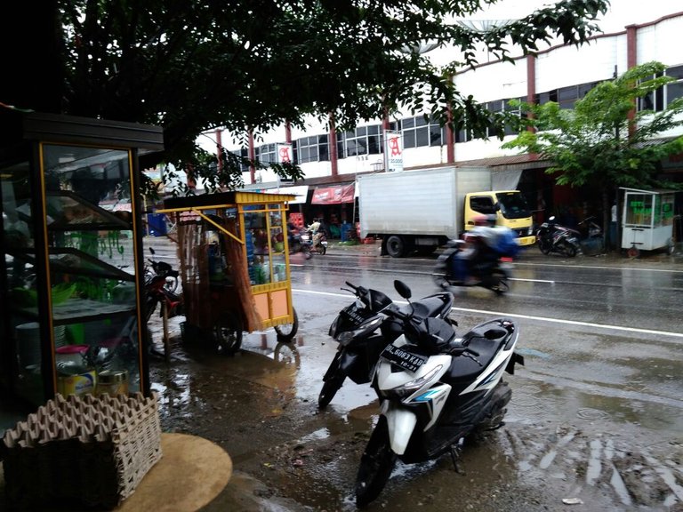
Hello @xpilar, I have really exited for contribute on you contest. This time I'll present a picture of the beauty scenery from my village.

Most of my villagers work as farmers, traditional stone miners and the lumberjack wannabe.

The hanging bridge above is the link between my village and the other village. The bridge was built in 2010, built in and financed by the navy.
My village is above the hills flanked by two great rivers, Badeng and the Kumbo river. In this picture is only the Badeng river that I photographed because the rain has started here.
That's just sort story about my village, this picture and story from my own post. Hope you enjoy the scenery @xpilar. Thank you.
love it, Very natural scenery buddy
Yes, thank you bro, thats one reason why I'm so proud with my village.
I'm proud to see your picture, Very amazing
Great pictures and information @coinfarmer
Thakyou @xpilar
This is Lhok Mee Beach or famous by the name of White Sand Beach Lhok Mee. this beach is one of the most beautiful tourist attractions that exist in my home town that is Aceh. This beach is located in Lamreh Village, Aceh Besar District. Lhok Mee Beach is just 2 km from Malahayati harbor, or 40 km from Banda Aceh City.
On this beach you will be served lined with tall wood trees reaching ten meters on the beach.
On Saturdays and Sundays, many residents are vacationing on Lhok Mee Beach.
Looks fishing boats that are used to find fish.
Lhok Mee Beach is worth your visit for an excursion.
This is my Aceh loen sayang.. my Home town.
Come my friends..
Visit my Aceh.....
Love your pictures, it's just beautiful @ollya
thanks
nice @ollya
thanks
Very good information and also wonderful place scenery picture, followed you buddy
thanks
my pleasure
The beauty of home my home town Sukabumi ... Love Nature

Hmmmm…. So the overseas people are not as comfortable as before, let alone observed in the profession as a regular student. Difficult to earn own income. Yep .. at the age of 19 this year to eat, tuition and other living expenses still rely on subsidies from parents. Shame really, really embarrassed. But, look for work that the term "part time" is also a bit difficult here. So what can I do, now yaa really study first wrote before entering the world of work later said my parents.
Sometimes students sometimes need "refreshing" to cool the mind of the assigned task of the lecturer, moreover many revisions of papers or other errors. Arrrghhh ... Students in my campus usually they climb the mountain, either emang hobby or indeed they are city people who already bored with views of buildings and malls. Different ama me that emang originally mountain people. Haha .. joking. But emang my house is at the foot of the mountain bark. Hehe .. Kalo dizzy again the same task college, it's like to go home. Look at the faces of my parents and my younger siblings at home. No need to walk to the tourist attractions because emang according to my hometown tuh already kayak tourist attractions. Believe or not, my hometown is really beautiful with nature. How baseball, from my house can see 4 mountains of Salak mountain, Mount Halimun (still his son's mountain salak maybe hehe), mountains wayang and mountain gede, and if in portrait beuuuhh really cool. Can dapet sunrise behind the big mountain sunlight nyorot to the expanse of rice fields deket home. In addition, in my hometown there is also a lake called Sukarame lake. Okay, my own house is in Kp.Cileuleuy Sukatani District Parakansalak Kab. Sukabumi West Java, Indonesia. Okay, for more information to describe my hometown, let's take a look at pictures below .. Cileuleuy Sukatani District Parakansalak Kab. Sukabumi West Java, Indonesia. Okay, for more information to describe my hometown, let's take a look at pictures below .. Cileuleuy Sukatani District Parakansalak Kab. Sukabumi West Java, Indonesia. Okay, for more information to describe my hometown, let's take a look at pictures below ..

Well, I took this picture in the morning, it's about 05.30 AM. You guys can see the beautiful Gede Mountain and the blue sky before the sunrise. The photographs fit sunrisenya ..
Yeah, the sun is rising behind Gede Mountain. The air here is pretty cold, if the morning can be 17 degrees Celcius (my accuweather said hp) and if the hottest lunch ampw 28 drajat celcius. Not bad. Usually every day, I never pass through the sunrise in my hometown, too beautiful to miss. Hehe .. Usually after 6 hours I directly "jog" to there sukarame, the distance is approximately 3 km doang from my house. The place is really nice bro, cool dah .. Nih place ..

The story is very long about this lake, once the Dutch say that this name is "park under salk", because the Indonesian people especially the Sundanese origin denger, they say "parakansalak". This lake is not a natural lake but an artificial lake. Created in the old days pas dutch still colonize Indonesia. It is said that this is a dam (Sundanese language) which is indeed a meeting of 7 rivers. And this lake is right under the mountain bark. But unfortunately really mountain salaknya not photographed because of blocked cliffs and hills. But there is a mountain that is visible from this lake that is wayang mountain. Try deh scrool again up there is a mountain, it's called wayang mountain. Uniquely this lake has a small island in the middle, different from other lakes. Hehe. Usually if I'm jogging from home at 6 am until the lake is around 06:35. so good at this lake, usually I ngadem until 08.00. Hahaa .. Not ngelamun cuman again mentadaburi nature. Really Beautiful Nature of God's Creation ... Well, abis come home from the lake, usually I take the road back together the same way to go, because pengen ngaliwat alias path through the rice fields. Hehe. And again the scenery is also not less cool ,. This time the appearance of the mountain of barking, wayang, halimun and mountain gede at once in one glance. Sok mangga tingali ku hidep .. galaxy and mountain gede at once in one glance. Sok mangga tingali ku hidep .. galaxy and mountain gede at once in one glance. Sok mangga tingali ku hidep ..


The mountains are mountains of wayang, halimun and mountain bark. While the misah own emang position is a little far from the view of the big mountain. and there is one more that I seneng from my house, kalo open the window of the room, look pemandagan that subhanAllah cool ..
Yapp. This is my hometown that has become the most comfortable place for me in this world. This is my village, where is your hometown Thanks.
Wonderful scenery picture, Very natural , Voted
Great pictures and information @kitomah
I live in Norway and here many also have to have the help of their parents to study
Even though Norway is now a rich country, it is a strict policy so that it is fodder on the planet that must be fair. While working part-time here too
I just know the information for a strict policy of your country, Nice to hear new information about

Most people are doing well in Norway, but this is also common with many children's families
And not easy at schools to have enough money to drive, everything is expensive in Norway now.
What happened in Norway now may be different from few years ago, Many people from Aceh in the conflict time out of area and Looking for political asylum abroad, and one of the countries they occupy is Norway, And I see that even though Aceh is peaceful after conflict their never go home, I think life there is easier than other countries, Norway is one of the famous scandinavian countries various policies that favor the public.
We welcome many immigrants and they must also be taken care of. It costs.
Most people have a good life in Norway. But families who have children who are going to study fever must help
Hmmm.. I knew now..most people have not a good life in my area, But their children who are going to study here in compentation of the Goverment, and just the rich families does not compentation for the study from Goverment. it's the differences both our country sir I think, Thank you for share it, How to make conversation with you? I don't meet your name in steemchat sir :)
Asyuth big home town
Asyuth or Asyut (Arabic: أسيوط) is a city located in the governorate of Asyuth, Egypt.
The city is located 375 kilometers south of Cairo, and in the Early Between Age, the city was named Zawty. Asyuth is the 13th capital of Upper Egypt.
Although Asyuth is famous of ancient Egyptian sources, the remains of Ancient Egypt remained in the Asyuth cemetery, located in modern western Asyuth. Most of the cemeteries found here come from Dynasties IX, X, and XII. The writing contained in the cemetery provides important information on the conflict between the Herakleopolis IX and X and the XI Thebes dynasties.
In the Greco-Roman period, the city was named Lycopolis.
Thank you for sharing with us @geutah
that's pic of my home city Abbottabad situated in Pakistan.
great, lovely to see the lights from the city @iwant
very very good story
Hy @iwant lovely picture, in Night so beautiful scenary
Hello @xpilar, I'm a newbie here who accidentally found this post, so I decided to follow this contest. Picture take a week ago by my self.
This is one of the famous beaches in my place, its name is Red Island.
Red Island Beach is favored as one of the exciting family tourist destinations. This place is the perfect place to enjoy the dusk and the typical beach breeze.
On this beach I used to enjoy the view of the sunset. The charm of the sunset can be said as one of the spectacular scenery that this place is served. Although called Red Island, the sand on this beach is not red but rather a bit brownish white. New when the dry season arrives, this beach area will look red.
This is my story for the first time and my first post also. Thank you @xpilar.
Welcome to the competition @popoo
The picture is very beautiful and thank you for your information
Thank you @xpilar, I'llbe exited to join another contest from you.
Nice to hear @popoo
My Home town
: and other public services, for those luxuries that are to some extent fulfilled. Life relying on a canoe and living in a house on stilts is typical of Batu Pengkalen residents. A total of 120 Batu Stone people everyday use the boat as a means of transportation. Appeared on Friday afternoon ago, dozens of boats tied in the marshes of the River Factory. The swamp is the entrance to the village of Batu Pengkalen which is decades isolated and without adequate public service facilities. This boat is used to carry the corpse, because the village does not have a Public Cemetery (TPU). "
Everyone who died we took him using a keranda, then put on a boat, it is difficult if the dry season, the water often receded, the residents must push the boat first to the middle to the boat road," said Pardi, citizen Pengkalen Batu.
That location became the main point of the River Factory to go to Batu Pengkalen. Vice versa. Although including the South Bangka regency, this village is closer to Pangkalpinang. From Pangkalpinang, residents or migrants travel a distance of 93 kilometers to reach Pengkalen Batu. Pardi is quite adept at rowing a boat carrying Bangka Pos along the forest and swamp that is wide enough. According to Pardi, Pengkalen Batu residents have been relying on river transportation for decades. No other access can be used other than the River Factory flow.
About 20 minutes sailing from Ranggung Village, Bangka Pos arrived at the Batu Pengkalen boat base. Naturally Pardi must be adept at rowing a canoe. The river flow along with Bangka Pos is quite winding and narrow. The Batu Penkalen settlement area is about one kilometer from the boat base. The graveled dirt road brings Bangka Pos to a village that relies solely on electricity from the diesel and solar powered engines. Pardi calls solar panels recently enjoyed by Pengkalen Batu residents.
Good info and nice pictures @hesteem
my home town Kampung Bajo Sampela, a village life story above the reef.
The bridges that stand on the pile which in some parts has been shaped like a concrete bridge the community kinship here. Down and down the little kids running around with their peers. The little boats seemed to be moored regularly in small canals that were actually sea. The "Apo" arrangement or the rocks that form the foundation of their yard look solid. It was a very modest evening in a village standing in the sea of kaledupa, the village of Bajo Sama Bahari.
It used to be called Kampung bajo Sampela village. But now this village changed its name to Sama bahari. This bajo tribe village is located not far from the mainland Kaledupa, Wakatobi. I use a small robin-engined boat that takes about 15-20 minutes from the Kaledupa mainland. And a small pier welcomes me as I enter this marine village of Sama.
Little boisterous kids gathered at the dock when I arrived. They look very enthusiastic with the immigrants. My step was directed to a house of the father of the village head of Sama Bahari village. After meeting and expressing the purpose of arrival, I went back down the path that is actually a small bridge that stood on the sea.
These bridges seem to be a link between the families in the village. But I also found some homes that have not been connected with this tiny bridge. If you have this story, a small boat is their means of transportation. With that little boat they do everything. From taking water to the ground, shopping, fishing, or just visiting relatives.
The origin of the existence of the Bajo tribe is still confusing. Some argue that this tribe was once a migrant from the South China Sea, but there is also a version explaining that this Bajo tribe is a follower of King Sameng in Johor who is looking for a princess who was married to a prince of bugis and settled in Sulawesi. From whence the origin of this tribe is very unique. In fact they got the nickname of the sea Gipsy.
Once these bajo tribes were known as boatmen, as they lived on boats. But over the times Tribe has started to recognize technology and settled life, although not far from the sea, even still in the middle of the sea. The reason why they are never far from the sea is because the sea is their field. They used to earn a living and live their lives at sea. The fish they catch in the traditional way in the middle of the sea are usually sold to Wanci mainland, but usually there are boats steaming fish catches in this village, so they do not have to go all the way to Wanci.
This tribe believes in "Umbo Mandilao" or the sea guard. They used to call this sea-guard with an ancestor living in the sea. They always believe that Umbo Madilao is always adding fish in the sea so as not to run out even though every day they catch. And they also believe that the sea guard is the one who always keep their life at sea anytime.
Labuka, this Sama Bahari village youth took me to his house. The fish that cultivate that night around the village we will burn in the yard of his house. Kampung darkness that night. But I am grateful with the darkness of the village I can see thousands of stars scattered in the sky right above this village. While making my fire tingle with the dark conditions of the village, what is this? Has not electricity reached this little village yet?
It turns out the questions in my heart in Labuka answer with deep inner tone. "Maybe the genset is damaged bang, or no one paid to buy oil for generator" a sentence slid from the mouth of my new best friend. And it turns out to turn on the generator they have to pay two thousand rupiah per house per night. Heiii to two thousand silver really means for information here, where is the conscience of our officials in the city of Jakarta Far away there, to the extent that they do not see the life of a village far from the glittering city full of facilities.
Fresh sea fish ready for us to burn. Meanwhile Labuka brought a bowl of saltwater as a natural spice for the fish to be burned. 2 cassowary shapes that are formed like a small cone are also ready to accompany. Kasuami is processed food from cassava that is grated and cooked. Approximately thousands of stars, above the village in the middle of the sea I eat fresh grilled fish and casuami are delicious, Labuka entertain me with a regional song that he sang. I do not know the meaning of the song, but what I capture from the outgoing tones is the bitterness experienced by the Bajo tribe, the village where Labuka was born and lived. The village has not been touched by the uneven development in the country. Ah well, this Sama Bahari Village teaches me about a way of meaningful life in a simple way.
Good info and nice pictur @kahlom
My home town
Al-LASHT
Al-Lasht village is one of the villages of Al-Ayat center in Giza governorate in Egypt. It is one of the important archeological sites, which has Pharaonic monuments, and the area where there is a pyramid. "Lasht" was called in the Pharaonic era, "Thawi"
meaning holding on the ground.
http://img.youm7.com/ArticleImgs/2016/10/28/70738-قرى-الجيزة-تغرق-فى-مياه-الأمطار-(13).jpg
The capital of Egypt was taken at the beginning of the Middle Kingdom era. A complex still obscure to the existence of its most mysteries and archaeological treasures still buried underground in this area, described by the archaeologists in the pristine region, which has not come close to any archaeological nearly a century ago. The capital of Egypt was taken at the beginning of the Pharaonic ages. The area is an extension of the famous Manfeh cemetery, located south of Dahshur, 50 km south of Cairo.
King Amenemhat the first is the one who established this area where he built his pyramid group consisting of the valley temple and the ascending road and the funerary temple and the pyramid named his name and around it there are tombs dedicated to senior men of the state in his time were revealed some at the beginning of the last century by an archaeological mission
Great pictures and information @juahsteem
This beautiful beach is only in my home town, called Belitung.

Belitung is famous for its beautiful natural attractions that captivate thousands of tourists to visit this island every month. The beauty of belitung tourist attractions increasingly famous when the island became the background of the scene of the film is quite phenomenal, the rainbow of the rainbow. So do not be surprised if today many people call the island of belitung as a land of warriors of rainbow. Because belitung is an island, then the mainstay of tourist attractions in belitung is a famous beach beautiful and has characteristics that can distinguish it with other beaches in Indonesia. If you've ever watched a movie laskar rainbow, of course you know one of the uniqueness that is on the beach belitung.
To enjoy the beauty of belitung attractions you can take two transportation options to this island. First through the airway, distance about 1 hour drive from jakarta. The second is by land route, which of course the distance is much longer than the air path. When you get to belitung, of course you want to enjoy the beauty of the famous tourist attractions in belitung that right?
in the photo that I uploaded this is a high cape beach, one of Belitung tourist attractions. The beauty of the high shore beach lies in its very white sand and its clear water. In addition, granite stones on the beach are typical of the coast of belitung, and the granite stones on the beach of the high cape are the largest stones among other beaches.
This my story about my beautiful Home town.
Visit my home town..
Your photos are very good, looks like a paradise @abujaga
Peace of Village Life Always Able to Provide Coolness of My Village's Home Page Bokor
The village of Bokor - Indonesia is very rich in culture and has thousands of beautiful islands, the people of Indonesia are very friendly.
Tired with urban dusk. bored with the rituality of work. Joom try it first break a bit, refresh the mind by enjoying the peaceful village atmosphere witch nostalgic at the time we were small earlier in the village.

The village does not offer a complete sundry life as seen in urban areas. limited employment does not exist, electricity is not evenly alive 24 hours. but the life of this humble village can make ourselves longing in peaceful coolness becomes more useful.
Well start from seeing the activities of villagers and villagers village bokor famous with very cheap smile and hospitality when we nyapa her.
Other activities of the community of bokor impact some of the stall sales of a kind of food gap, the market is limited if in our city will easily find the market, whether traditional markets, modern markets or even the market shock that is often said seasonal market. then it would be different if we live in the village, the article in perdesaamn it is very limited and in certain places only. Well in the village we see his villagers bokor with his own try can sell all kinds of eating markets ..


They can only peddling laps sales with potluck on the edge of the harbor road bridges access crossing into the city or village. harapan their future hoping there is a decent place sale shop Article village.
Childhood is the most beautiful and memorable time in our lives. We are content to play without thinking about money and others. Wherever we go through our childhood and our childhood is still the most beautiful we will remember. We are also a lot of friends to through joy and sorrow.
Great pictures and information @aronna
Surely you already know what it is called a village. The village is a place away from urban areas, tall buildings and bustling streets and magnificent malls.
few people say that the village is a place that is not clean, slum and also away from information and lack of communication,
Well, here I will explain that all the problems are not a problem because on the one hand we want the silence of the freshness of air or any area asri.sebagai definition I will explain what are the advantages and disadvantages of living in the hometown.
Friendly Village atmosphere
Compare when we are in urban areas when we meet passers-by and nobody greets because we do not know them, but if we are in the country it feels very comfortable when we meet someone we do not know the person would smile and friendly greeting from the previous do not know we can easily with them.
Cool Air
If we are in urban, there must be many vehicles passing by and removing smoke from the exhaust and making the air very unpleasant in the inhalation and causing pollution which is not good for health but if we are in the countryside or village we will feel cool air clean and avoid pollution. The abundance of trees, vast rice paddies and towering mountains make it a beautiful sight that our eyes see.
Clean Place Whose
word in the village is a dirty place? if we look like where exactly in the city even more dirty especially if clay sewer ditok always filled with smpah we try to compare with the gutter that we assume dirty when we see the ditch in the village look very clear and beautiful.
That is why I am more comfortable living in the hometown that people say is plebeian but this is where the most comfortable to live because the comfort of people can think clearly and can be easy to be grateful so do not keep looking up so that makes people are not satisfied with the we have
Where the place? Very Natural scenery
Great pictures and information @irsyadhidayat
Krueng Geukuh Beach is a tourist spot located in North Aceh, located close to Krueng Geukuh Public Port which offers clean white sand beach and unique culinary ie Mie Aceh.
this photo was taken by me...

Not only known as the industrial area, North Aceh was also save a variety of beach tourism is quite interesting to visit. It is not strange if many found exotic beaches in North Aceh, because this area is directly adjacent to the Straits of Malacca. Krueng Geukuh Beach is a few examples of coastal lines scattered in this district.
Krueng Geukuh Beach is a popular beach in Aceh province, especially people around North Aceh and Lhokseumawe. The specialty of this tourist spot is located on the sand beach is always kept clean. This is not separated from the awareness of the surrounding community is very concerned with cleanliness. In addition, on this beach tourists can also find a fascinating sunset phenomenon.
Geographically, the location of Krueng Geukuh Beach is located in Dewantara District, North Aceh Regency, Aceh Province. To go to this beach tourists should at least travel about 56 kilometers or travel for approximately one and a half hours from Lhoksukon. However, if tourists come from Lhokseumawe, then the distance is close enough only about 30 minutes.
There are several transportation options that tourists can use to get to this Krueng Geukuh Beach. Public transportation such as buses, public transportation or often called labi-labi, motor rickshaws and taxis. In addition, tourists can also use private vehicles by choosing the Medan-Banda Aceh route.


ok kan..
Good info and nice pictures @abuteungeut
Our town is small, but we have a beautiful church, a park with our own airplane), concerts on the streets, funny animals in yards...
( )
)
Beautiful pictures from your city@ir3k
nice @ir3k
Very nice to see the scenery of your town, I followed you now, want to more abaout you there
hometown, the most comfortable place we have, that's where we first know the world, on the ground that we first to our feet on earth, there we are taught how to survive, and the other side of life .. hometown could be the most missed place especially for the immigrants who have long since left their hometown to try their fate in another city or abroad for a hope and a dream. a collection of poems homesick homes, is a collection of some poems that I try ketengahkan, to express a little longing deeply for my beloved hometown.karena like whatever our hometown, or how comfortable we live there first, is the hometown was the most comfortable place ever we have
Well-told and beautiful picture @apasyam
Aswan Nubian home town
Before I went to Aswan, I only knew about the big dam. I still remember when I was in high school, the Aswan dam became one of the topics in world history lessons. After setting foot in Aswan, I realized that Aswan is apparently not just a matter of a dam. There is little less than the high school world history lessons about Aswan because the books do not mention the civilization of the Nubians, the tribe who inhabited Aswan thousands of years ago. In fact, Nubian civilization as old as Egypt civilization. The progress of their civilization can be seen from the archaeological sites they build. Unfortunately, many of the Nubian sites and their settlements were "drowned" by the Aswan dam construction
Great picture and information @apamae
i live it bahreya town karchi .
bahreya town is situated in pakistan .
the construction of behreya town is continue & the ower of behrea town is Malik Riaz .malik Riaz is the richest man of Pakistan & he invested a lot of money on behreya town
Wow, An Amazing picture dear
thanks dear
Amazing picture, thanks for the information @hanitasteemer
home town
a city in our country namely Indonesia is also called the rain city
Yes, it seems to be raining in your pictures as well @baroen96
ha ha ha ha ha you right sir, Have raining for a week here in Aceh, Indonesia
nice @@@baroen96
Ujan-ujan Ie kupi baru mantap @baroen96 followed you
that's nice!
suggestion : maybe you could ask them to tag it #xpilarcontest as the first tag if they decide to make a post about it instead of posting in a comment
then you won't have a hard time looking for their posts nor miss one
how about that :)
where's your 7blkndwhte? :D
haha
Thank you so much for your great idea, have not thought about it @englishtchrivy
I'll do that next time because it's a lot of work the way I do it now.
My next picture will be coming soon but it will be number 6 blkndwhte
I'am agree with your opinion @englishchrivy to tag in #xpilarcontest , Followed you, much love from Aceh, Indonesia
Done....see my latest post please. Thanks @xpilar for this great contest
Thanks @rooneey
So sad that I don't know how to post a photo here. The photo was saved in my facebook account, trying to copy it here but I can't.

Hi @lisaocampo
You go to this link and upload your photo
http://postimages.org/
Once you have done, select the Direct link:
and paste it into the comment field
https://m.facebook.com/story.php?story_fbid=10211062031206662&substory_index=0&id=1232092091
Suppose you made a mistake here with your link. Your link goes to an empty Face Book page
You have to read the rules, this is a competition @lisaocampo
Good Luck to everybody who is participating in this contest )
)
(
Ok sir I understand and now going to write it.
yes and with pictures @funatoz
ok lets see who wins

you're welcome @rajag234
Leave a comment on your blog now
ok ...i will try
Nice to hear @rajag234
Hello @xpilar, here is my entry to your hometown contest. Many thanks to @dilimunanzar who introduced me to team xpilar. Have resteemed, upvoted and followed. I don't know how to post with all photos embedded in this comment. Please check out my entry here https://steemit.com/contest/@ainie.kashif/hometown-contest-visiting-my-forgotten-childhood-days
Go Team x-pilar!
Hi @ainie.kashif
You go to this link and upload your photo
http://postimages.org/
Once you have done, select the Direct link:
and paste it into the comment field
Thanks @xpilar, I have registered on the website, will try to post my story here... hahaha I feel so old school :)
I'm fine, I voted for your side, okay I'm fine, I voted for your side, okay
Good info and nice pictures, like video
have visited your page @ainie.kashif
Hy Bunda @ainie.kashif nice to meet you here :)

For easy way I think you just copy the link of your post image tu put in comment
and tell the story of your post, I did like this one always, But if you did'nt have the picture from any post of your blog you can't do this way Bunda
Tak boleh ananda, bunda guna mobile phone bukan pc, susah sangat rasanya. Rasa bunda ini sangat-sangat ketinggalan zaman. Orang-orang lama memang macam gini.
Tak ada orang orang lam, Tak adalah orang-orang masa kini, Tapi tidak apa-apa kok bunda, Kedpannya contest x-pilar akan kita usulkan untuk memakai sebuah Tag, yang nantinya bisa di ikuti oleh setiap steemian dari berbagai Negara lainnya untuk menjalain persahabatn lintas virtual ini.